
“Take your own route, not the route everyone is using or taking. Create your own way; there is always traffic on the common route.”
― Israelmore Ayivor, 101 Keys To Everyday Passion

Choose Your Season for Route:
Some Popular Routes, See Elevation Mapping Below
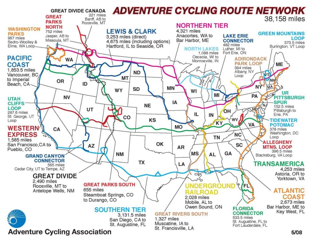
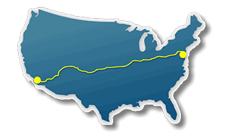
Routes
What is the best route to bicycle across the United States of America?
Bicycling across the United States is an incredible adventure, and there are many possible routes to take depending on your preferences and goals. Some of the most popular routes include:
1.	TransAmerica Trail: This route stretches over 4,200 miles from Astoria, Oregon to Yorktown, Virginia, crossing through 10 states and many small towns and historic sites along the way. The route is well-marked and maintained by Adventure Cycling Association, and offers a mix of terrain, from the rolling hills of the Appalachians to the flat prairies of Kansas.
2.	Northern Tier: This 4,285-mile route starts in Anacortes, Washington, and ends in Bar Harbor, Maine. The route takes you through some of the most scenic areas of the country, including Glacier National Park, the Adirondacks, and the Great Lakes region.
3.	Southern Tier: This route spans over 3,000 miles from San Diego, California to St. Augustine, Florida. The route takes you through the southern states, including Arizona, New Mexico, Texas, Louisiana, Mississippi, Alabama, and Florida. You'll experience the diverse cultures and landscapes of the southern US, including deserts, mountains, and coastal regions.
4.	Pacific Coast Route: This route stretches over 1,900 miles from Vancouver, Canada to Imperial Beach, California. You'll ride along the coast of the Pacific Ocean and experience stunning views of the ocean and mountains. You'll also pass through cities like Seattle, San Francisco, and Los Angeles.
5.	Great Divide Mountain Bike Route: This route is a challenging off-road option that takes you over 2,700 miles from Banff, Canada to Antelope Wells, New Mexico. You'll ride through the Rocky Mountains and encounter rugged terrain, including steep climbs, rocky trails, and river crossings.
Before embarking on any of these routes, it's important to do your research, plan your itinerary, and make sure you have the appropriate gear and training. Consider joining a group tour or traveling with a partner for added safety and support.
Transamerica
Trail Rail
Traditional ROute
Bicycle Routes Across America
Bicycle Route Maps
Cycling across the south
As you plan your bike ride across America, you have to decide how far you want to ride and over what kind of terrain. The shortest routes start or finish in San Diego, California. Looking at a map, you will see that San Diego is east of Reno, NV. Adventure Cycling’s southern most route goes east to St. Augustine, Florida for a total of 3110 miles. A bicycle touring company starts a little north of San Diego, traveling to Savannah, Georgia for a total of 2912 miles.
Cycling Across the Central US
 Bicycling across the central portion of the United States perhaps offers the most routes. Distances vary widely. One of the shorter, well researched routes is The Race Across America , an endurance cycling event, begins in Oceanside, CA just north of San Diego and ends 3000 miles later in at City Dock Annapolis, Maryland. While you may not be interested in racing across America, their maps are worth a look. Crossing 12 states and climbing 175,000 feet, they are well researched and tested for bicycle use. You can also import the GPS way points to use with your Garmin Edge or other cycling friendly GPS unit. The 2019 race begins June 11. The pre-race materials include route proflies with climbing totals as well as driving directions.
Compare the RAAM distance to the much longer Adventure Cycling Transamerica route which terminates after 4262 miles.
Bicycle Across the Northern States
Here too you will find several options. I found a listing for a trip from Astoria, Oregon to Portsmouth, New Hampshire totaling 3629 miles. This trip ferries across Lake Michigan.Adventure Cycling’s northern route begins in the far northwestern tip of the contiguous United States in Anacortes, Washington, travels to the south of Lake Michigan, ending further north in Bar Harbor, Maine, for a total ride of 4322 miles. On the RAAM site you will also find their route climbing chart. I have driven part of their route across southern Colorado. Knowing the elevation changes could be helpful in your bicycle trip planning. U.S. Bicycle Route System
Bicycle Routes
U.S. Bicycle Route System
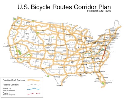
Many routes currently exist, including Route 76. Route 76 officially exists in Virginia, Kentucky and Illinois. Route 76 is signed in western Kentucky.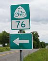
National Bicycle Corridor Plan
Adventure Cycling Association is on the task force of AASHTO (American Association of State Highway and Transportation Officials) “charged with developing a national corridor-level plan and designation system that transportation agencies can utilize for the development of bicycle routes.” Over 13,000 miles are ridable in the USBR sysyem. You can find more information and download maps here: U.S. Bicycle Corridor Plan Map
Adventure Cycling Association Routes
 Adventure Cycling Association has a great collection of detailed maps for bicycling across the USA. Their tag line is “America’s bicycle travel experts.” They now have cycling maps covering more than 41,399 miles. Their oldest and most used route is the TransAmerica. This set of maps covers from Astoria, Oregon to Yorktown, Virginia a distance of 4252 miles. In the early 1990s I rode parts of this route in Kentucky and Virginia. The route uses many secondary roads, avoiding busier roads most of the time. Adventure Cycling releases regular updates with information on camping sites, motels, where to get food and other important services. As a member you will receive a discount on your purchase of maps and cyclo-touring equipment.Adventure Cycling Association is nonprofit with a mission to “inspire people of all ages to travel by bicycle for fitness, fun, and self-discovery.” If you’ve been a cyclist for a long time, you may remember them as BikeCentennial. Here are links to their bicycle maps. TransAmerica bicycle route maps
Northern Tier
Adventure Cycling’s route across the northern United States is the “Northern Tier.” This route is from Anacortes, Washington to Bar Harbor, Maine. This is the longest route at 4322 miles. Two sections of the map will be changing for 2012 because of changes in traffic to Minot, ND due to oil drilling activity. This route stays near our border with Canada. I will be riding this route starting in May 2012. You can follow me progress on my blog at this site: Bike Across USA Blog We are looking forward to seeing Glacier National Park and ending with a ride up Cadillac Mountain in Acadia National Park. Note that Adventure Cycling says the two revised map sections will be available in late April. Northern Tier bicycle maps
Adventure Cycling’s shortest route across the USA is the Southern Tier Route from San Diego, California to St. Augustine, Florida Southern Tier Route This is a ride of 3110 miles. If you have a GPS device, Adventure Cycling can provide GPS waypoints. You need a GPS device with upload and download capability. Here is a link to their page with more detailed information. GPS information for bicycle routes
North to South Tours Across the USA
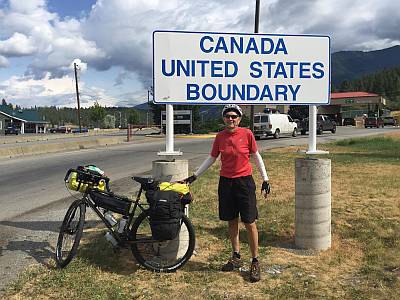 When I began this site more than a decade ago, I was thinking about coast-to-coast rides. In 2012 I gave a speech at my local Toastmasters Club about my plan for a ride from the Pacific Ocean to the Atlantic Ocean. In 2014 I rode from Canada to Mexico along the Pacific Coast. Still I didn[t change the routes talked about on this page. In 2018 I bikepacked a portion of the Great Divide Mountain Bike Route starting at the Canadian border at Roosville, Montana. The GDMBR as it is called, zig-zags across the continental divide as it heads south toward the Mexican border at Antelope Wells, New Mexica.
My current plan is to add more about the GDMBR, bikepacking and other routes starting in April 2019.
Elevation Mapping

Check out
BikeRoll | Bike route planning with elevation map
BikeRoll helps to plan road bike and mountain bike routes on Google maps with elevation profile. The color-coded altitude profile of the bicycle track is

BikeRoll.net https://bikeroll.net › …
